Rate this trail

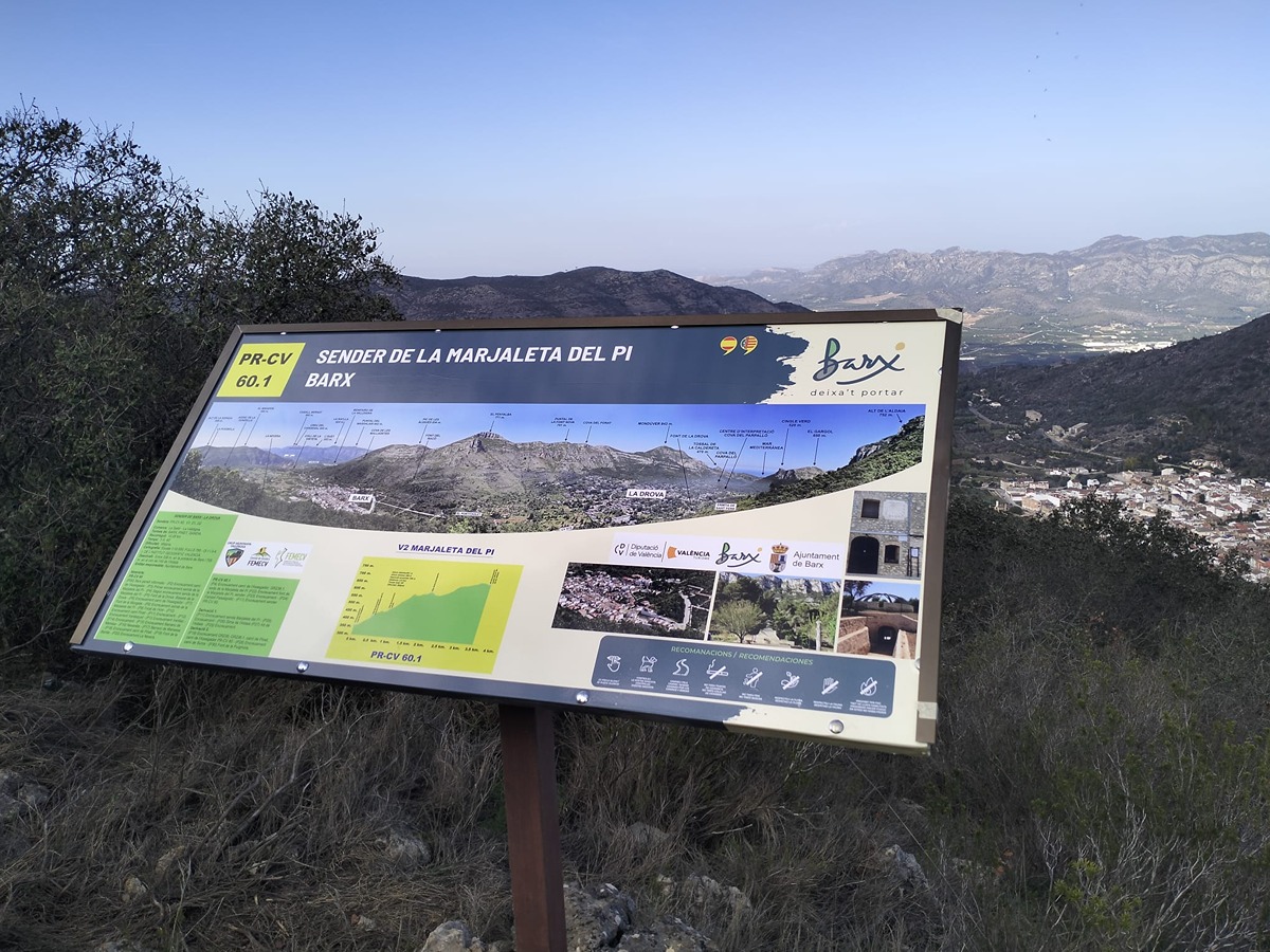
PR-CV 60.1 SENDA DE LA MARJALETA DEL PI

Promoter: Ayuntamiento de Barx

Certification status: Positive quality control

0 reviews

Variant that recovers the ascent to Pla de les Simes by the path of Marjaleta del Pi.

Trail:
One way (point-to-point)
Technical data:
Length:
3,50 km
Estimated walking time:
01:15:00
Elevation gain:
360 m
Elevation loss:
45 m
MIDE ratings:
Level of natural risks:
2
Navigation on the trail:
2
Hiking difficulty:
2
Fitness level needed:
2

More information on Montaña Segura

Difficulty rating according to FEDME:
Unknown
Starting point:
End Point:
Useful information:
Date of certification:
15-10-1994
Date of the act of registration in the Public Register:
22-05-2007
Date of the last Quality Control:
november de 2024
Reference municipality:
Otros municipios por los que transcurre:
District:
Province:
Valencia/València
Cartography IGN MTN25:
0770-4; 0795-2

Downloadable from the Catalogue of the IGN Map Library

See other trails of this promoter:
Protected Natural Spaces:

We advise you to look up the regulations and/or authorisations for using the trails in these conservation areas on the website of the Conselleria de Medio Ambiente, Agua, Infraestructuras y Territorio

  • El Surar (Municipal Natural Site)
  • Montdúver - Marjal de la Safor (SPAB - Special Protection Area for Birds)
  • Serra del Motduver i Marxuquera (SIC - Site of Community Interest)
  • Serres del Montdúver i Marxuquera (SAC - Special Area of Conservation)
Key points of the route:

Camino del Assegador (PR-CV 60 and GR 236.1 connection) (pah) – Fuente de la Marjaleta del Pi (spring) - Senda enlace PR-CV 60 (path) - Pla de les Simes (PR-CV 60 connection and derivation to Alto de Aldaia (peak))

Route description (only available in Spanish)

Desde el camino de l'Assegador, en la urbanización de la Drova, remontamos la ladera de la sierra del Buscarró hasta la fuente de la Marjaleta del Pi. Seguimos el ascenso y dejamos a la izquierda la senda que enlaza con el PR-CV 60 poco más arriba de la fuente de la Mongeta.

Ahora, el desnivel es más pronunciado y zigzagueante hasta alcanzar la parte alta donde se encuentra la sima de la Marjaleta. Continuamos hasta llegar al Pla de les Simes donde finaliza esta variante.

Downloads:

Beware! Navigation devices may fail, batteries may run out of power and devices may break down. Do not use only electronic means to track your activities in the mountains; they must be used as a complement to the map and compass. Get some proper training and enjoy the mountains.