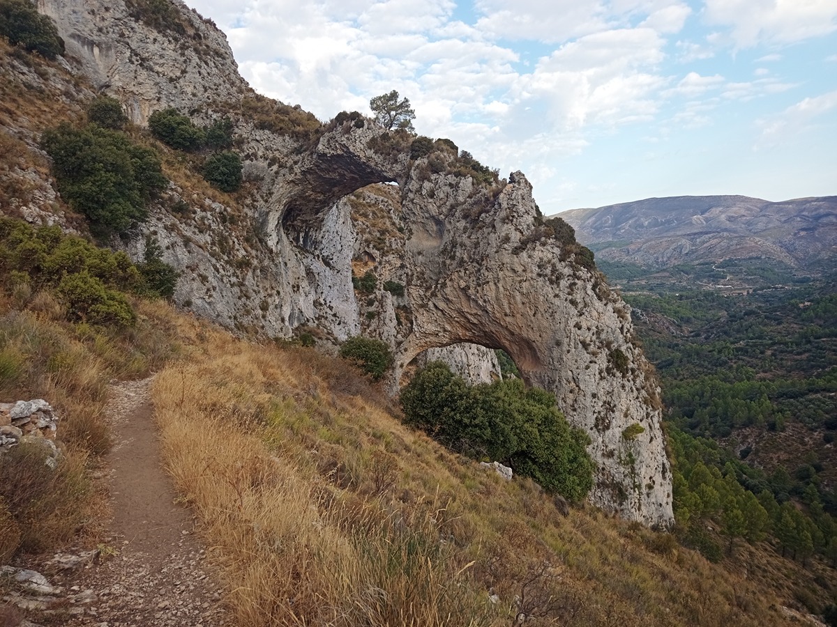
Rate this trail

PR-CV 151 ELS ARCS

Promoter: Diputación de Alicante

Certification status: Positive quality control

1 review

You will see the Xorquet cistern and reach the Arcs, an impressive geological formation that forms large arches.

Trail:
Loop with some overlapping out and back sections
Technical data:
Length:
6,90 km
Estimated walking time:
03:00:00
Elevation gain:
205 m
Elevation loss:
205 m
MIDE ratings:
Level of natural risks:
2
Navigation on the trail:
2
Hiking difficulty:
2
Fitness level needed:
2

More information on Montaña Segura

Difficulty rating according to FEDME:
Unknown
Useful information:
Date of certification:
15-01-1999
Date of the act of registration in the Public Register:
22-05-2007
Date of the last Quality Control:
november de 2022
Reference municipality:
District:
Province:
Alicante/Alacant
Cartography IGN MTN25:
0822-3

Downloadable from the Catalogue of the IGN Map Library

See other trails of this promoter:
Protected Natural Spaces:

We advise you to look up the regulations and/or authorisations for using the trails in these conservation areas on the website of the Conselleria de Medio Ambiente, Agua, Infraestructuras y Territorio

  • Aitana, Serrella y Puig Campana (SIC - Site of Community Interest)
  • Els Arcs (Municipal Natural Site)
  • Montañas de Alicante (SPAB - Special Protection Area for Birds)
Key points of the route:

Pla d'Aialt (plain) - Alibe del Xorquet (cistern) - Els Arcs - Penya Escoda (peak) - Pla d'Aialt (plain)

Route description (only available in Spanish)

Desde el pla d'Aialt seguimos el camino unos pocos metros más allá y encontramos a nuestra derecha las ruinas de uno de los corrales del Somo, seguimos por nuestra izquierda, encontramos otra casita a la derecha y una pequeña ruina de un corral, siguiendo el camino a la izquierda cruzamos el lecho de un arroyo (sin agua) y llegamos al Aljibe del Xorquet, a su lado un pequeño abrevadero, volvemos sobre nuestros pasos hasta el cruce, allí seguimos de frente, llegamos a otra bifurcación de caminos, seguimos recto, hasta llegar a un cruce, tomamos dirección izquierda para acercarnos hasta el Paraje Natural Municipal de interés que es Els Arcs, impresionante formación geológica, de camino apreciamos las ruinas de un corral en roca. Volvemos sobre nuestros pasos en el cruce ahora seguimos hacia Penya Escoda, de camino a Penya Escoda, a nuestra derecha encontramos el Corral del Poll, también tiene un pozo. Seguimos de frente, y al poco llegamos a un cruce indicador nos dice que yendo a la izquierda vamos a Penya Escoda, seguimos la indicación y llegamos a otro panel informativo donde encontramos información sobre el entorno, etc, volvemos sobre nuestros pasos, en el cruce tomamos la dirección del Pla d'Aialt, por un camino que nos conduce entre cultivos hasta la carretera, seguimos a la derecha, después de unos pocos metros por la carretera nos encontraremos de nuevo en el punto de salida.

Downloads:

Beware! Navigation devices may fail, batteries may run out of power and devices may break down. Do not use only electronic means to track your activities in the mountains; they must be used as a complement to the map and compass. Get some proper training and enjoy the mountains.

Other trails connecting with this trail