Rate this trail

PR-CV 321 LA PELMA - LA RICONÁ - LA BANDERA - LA PELMA

Promoter: Ayuntamiento de Chulilla

Certification status: No quality controls

1 review

There is no proof of quality control on the record of this trail in the last years. For this reason, it is unknown whether it complies with the optimal signage and maintenance conditions for hikers to take the trail following these signs exclusively.
Hikers have to take into consideration that the information about the signage and maintenance of the trails for which the promoter entity is responsible might not be up to date anymore, since it refers to its state on the date of its approval. Furthermore, mountain sports entail risks associated with the activity itself and the environment where they take place, for which any person is fully liable. For this reason, hikes need to be planned properly and adequate training, equipment and sensible use of the trails are required.

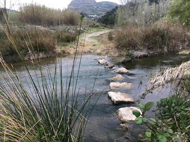
Trail that starts at the La Pelma spring, next to a recreational area. The trail borders on the mountain of La Bandera, partly along the Turia River. It has a variant leading to the Bandera viewpoint, from where you can enjoy the breathtaking landscape.

Trail:
Loop with some overlapping out and back sections
Technical data:
Length:
15,30 km
Estimated walking time:
05:00:00
Elevation gain:
565 m
Elevation loss:
565 m
MIDE ratings:
Level of natural risks:
1
Navigation on the trail:
2
Hiking difficulty:
2
Fitness level needed:
3

More information on Montaña Segura

Difficulty rating according to FEDME:
Unknown
Starting point:
Useful information:
Date of certification:
15-09-2009
Date of the act of registration in the Public Register:
20-10-2015
Reference municipality:
District:
Province:
Valencia/València
Cartography IGN MTN25:
0694-2; 0695-1

Downloadable from the Catalogue of the IGN Map Library

See other trails of this promoter:
Protected Natural Spaces:

We advise you to look up the regulations and/or authorisations for using the trails in these conservation areas on the website of the Conselleria de Medio Ambiente, Agua, Infraestructuras y Territorio

  • Alto Turia y Sierra del Negrete (SPAB - Special Protection Area for Birds)
Key points of the route:

La Pelma recreation area - Clochas de Targa - CV-395 Road - Path to Gestalgar - Path to La Majada - Path to La Bandera - La Pelma recreation area

Route description (only available in Spanish)

Salimos del área recreativa La Pelma por el camino de acceso a la misma para coger camino a izquierda paralelo a la carretera. Al pasar zona de cultivo encontramos cruce con varios caminos, seguimos de frente por senda para cruzar el Barranco del Corral Nuevo y llegar a la zona de Clochas de Targa. Por diversos caminos al oeste de la población de la Ermita llegamos a carretera asfaltada seguimos a izquierda, en el siguiente cruce de caminos con la CV-395 enlazamos con el PR-CV 76, en la curva anterior al puente que cruza el río Turia seguimos a izquierda por el camino a Gestalgar, inmediatamente llegamos a la Fuente de la Rinconada. Poco después en cruce enlazamos con el PR-CV 290, seguimos de frente. En la siguiente curva encontramos camino en ascenso a derecha, el cual cogemos, poco después el camino se convierte en senda. Esta cruza la zona de Los Picarchos dejando en la parte de abajo el Balneario de Chulilla, al cruzar el Barranco Sereno iniciamos subida con gran desnivel.Una vez en lo alto llegamos al Camino de la Majada, seguimos a izquierda hasta llegar a la inserjección con el Camino de la Bandera, el cual encontramos a izquierda.De este parte la variante para llegar al Mirador de la Bandera, una vez observado el espectacular paisaje que nos ofrece el mirador hay que retroceder para volver a incorporarnos de nuevo al camino anterior y seguir descendiendo por la zona conocida como 'El Losar', hasta llegar de nuevo al área recreativa La Pelma. 

Downloads:

Beware! Navigation devices may fail, batteries may run out of power and devices may break down. Do not use only electronic means to track your activities in the mountains; they must be used as a complement to the map and compass. Get some proper training and enjoy the mountains.

Other trails connecting with this trail