Cambiar idioma a español / Cambiar idioma a english / Cambiar idioma a valencià

Rate this trail

SL-CV 19 SENDA DE GAMELLONS

Promoter: Ayuntamiento de Ontinyent

Certification status: No quality controls

0 reviews

There is no proof of quality control on the record of this trail in the last years. For this reason, it is unknown whether it complies with the optimal signage and maintenance conditions for hikers to take the trail following these signs exclusively.
Hikers have to take into consideration that the information about the signage and maintenance of the trails for which the promoter entity is responsible might not be up to date anymore, since it refers to its state on the date of its approval. Furthermore, mountain sports entail risks associated with the activity itself and the environment where they take place, for which any person is fully liable. For this reason, hikes need to be planned properly and adequate training, equipment and sensible use of the trails are required.

The starting point of the trail is the Gamellons forest house, which can be reached from the Fuset and Pla de Simes road, at kilometre 9.38 of the CV-655 trail. This house was built at the beginning of the 20th century as part of the reforestation work that was being carried out at that time. Several ravines and two other paths converge near the south of the house, contemporary with the aforementioned reforestation works.

Trail:
Loop with some overlapping out and back sections
Technical data:
Length:
7,80 km
Estimated walking time:
02:30:00
Elevation gain:
230 m
Elevation loss:
230 m
MIDE ratings:
Level of natural risks:
1
Navigation on the trail:
2
Hiking difficulty:
2
Fitness level needed:
2

More information at Montaña Segura

Difficulty rating according to FEDME:
Unknown
Starting point:
Useful information:
Date of certification:
15-04-1999
Date of the act of registration in the Public Register:
22-05-2007
Date of the last Quality Control:
june de 2021
Reference municipality:
Other municipalities through which it passes:
District:
Province:
Valencia/València
Cartography IGN MTN25:
0820-1

You can download them from the IGN Map Library Catalog

See other trails of this promoter:
Protected Natural Spaces:

It is recommended to consult the regulations and/or authorizations for the use of trails in these protected natural areas on the website of the Regional Ministry of Environment, Water, Infrastructure, and Territory

  • Els Alforins (SIC - Site of Community Interest)
  • Serra de l'Ombria - Pou Clar (Municipal Natural Site)
Weather information:
Nearest AVAMET weather station
Key points of the route:

Casa forestal dels Enginyers (forester's house) - Pista de la Replana (track) - Senda de la Duenya (path) - - Font de la Duenya (spring) - El Grifo de la Cava - Cova de la Monja (cave) - Casa forestal dels Enginyers (forester's house)

Route description (only available in Spanish)

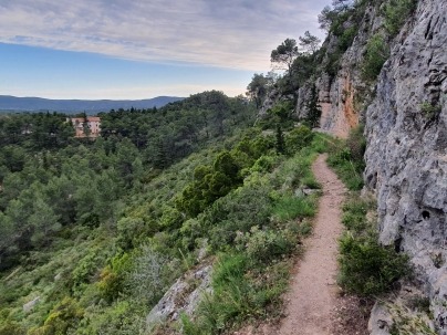
El lloc d'inici del sender és la casa forestal de Gamellons, a la qual arribem des del camí de Fuset i del Pla de Simes, al km 9,38 de la CV-655. Aquest casalot fou edificat a principis del segle XX per atendre les tasques de repoblació forestal que es van dur a terme en aquella època. En la rodalia de l'encarada sud de la casa convergeixen diversos barrancs i dos sendes d'enginyers, contemporànies d'aquells treballs forestals. Iniciem el recorregut per la que es troba a una cota lleugerament superior, anomenada també senda del Remallar. Als 250 m del començament, la senda circula arrapada als penjats exposats de la penya de l'Àguila, uns tallats rocallosos abocats al barranc de les Olles. Continuem travessant pinades frondoses i creuem el fons del barranc per abocar-nos ara al barranc paral·lel de l'Infern. Anem pujant cota suaument a mitja altura del vessant, amb bones vistes sobre els paisatges abarrancats que baixen cap al paratge de Gamellons. Arribem a la pista forestal de la Replana i la prenem cap a l'oest. Als 500 m de pista, per l'esquerra ens ix un senderol a través del qual podem acostar-nos a la font de la Simeta, una petita gruta que guarda un sumador a l'interior. Continuem per la pista fins que aquesta pren contacte amb un tallafocs, on l'abandonem i davallem per una senda erosionada cap al sud. Arribem al paratge fresquívol i agradós de la font de la Duenya i l'alcavor. Refem els nostres passos per la senda i retornem a la pista de la Replana. La creuem en direcció nord i prenem l'altra senda dels Enginyers de l'itinerari. La senda s'endinsa entre pinades esguitades de xiprers, restes d'antics treballs de forestació. Passem vora de la cava del Grifo, una excavació formada per dos galeries que recollien l'aigua de pluja necessària per als treballs de reproducció del planter forestal. Creuem un camí i la senda davalla per abocar-nos al barranc de les Cordelleres, i més avant de nou al barranc de l'Infern, a les envistes de la casa de Gamellons, a la qual s'arriba per una cota inferior a la de la senda del Remallar, l'altra senda dels Enginyers de l'inici de l'itinerari. Finalitzat el recorregut, podem visitar també la font de Gamellons, a 400 m de la casa, un indret ombrívol i humit amb un brollador ben cabalós i molt reconegut per l'excursionisme d'Ontinyent.

Downloads:

Beware! Navigation devices may fail, batteries may run out of power and devices may break down. Do not use only electronic means to track your activities in the mountains; they must be used as a complement to the map and compass. Get some proper training and enjoy the mountains.