Rate this trail

SL-CV 42 SENDA DELS LLADRES

Promoter: Ayuntamiento de Sagunto

Certification status: Conditioned quality control

1 review

Following the inspection carried out by trail technicians, this trail has been declared of "limited adequacy" as a result of the faults detected in the signage. These include inadequate horizontal signs (paint markers) and/or vertical ones (trailheads and information boards) or lacking direction markers that do not provide sufficient information to properly follow the route. The builder of this trail has been informed of the situation.
For safety reasons and during maintenance work, it is advised to be extremely careful while taking this route. Furthermore, mountain sports entail risks associated with the activity itself and the environment where they take place, for which any person is fully liable. For this reason, hikes need to be planned properly and adequate training, equipment and sensible use of the trails are required.

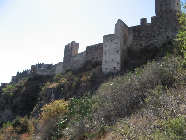
This trail allows you to walk around the entire perimeter of Sagunto Castle, while discovering different elements of the many cultures that have passed through its walls over the last 2,500 years of its history. Most importantly, it offers spectacular panoramic views which will help you understand the strategic importance of this military fortress along the walls of which runs the trail itself.

Trail:
Loop
Technical data:
Length:
2,40 km
Estimated walking time:
00:50:00
Elevation gain:
120 m
Elevation loss:
120 m
MIDE ratings:
Level of natural risks:
2
Navigation on the trail:
2
Hiking difficulty:
3
Fitness level needed:
1

More information on Montaña Segura

Difficulty rating according to FEDME:
Unknown
Starting point:
Useful information:
Date of certification:
15-04-2007
Date of the act of registration in the Public Register:
02-06-2009
Date of the last Quality Control:
june de 2022
Reference municipality:
Province:
Valencia/València
Cartography IGN MTN25:
0668-4

Downloadable from the Catalogue of the IGN Map Library

See other trails of this promoter:
Key points of the route:

Sagunto - Access to the fort and the Jewish Cemetery - Gate in the medieval wall - Civil War machine-gun nest - Views of Espolón Plaza del Dos de Mayo of Castillo de Sagunto (fort) - Remains of Iberian wall - Remains of Iberian houses - Els Tres Pouets (Iberian-Roman cisterns) - Hebrew hypogeum - Sagunto

Route description (only available in Spanish)

El itinerario comienza a los pies del teatro romano, ascendiendo por una escalera que nos lleva a su parte superior, bajo las murallas del castillo. Bordeando éstas hacia la derecha, se sigue una pista ajardinada que permite acceder al cementerio judío y a la puerta de acceso al castillo, con el centro de recepción de visitantes. Acabada la pista ajardinada, ésta se convierte en senda y atraviesa un portal pétreo de la antigua muralla, próximo al cual se encuentran los restos de una posición defensiva de la Guerra Civil española. Desde allí, ya todo por senda, se accede a una amplia zona a los pies de la plaza del 2 de Mayo, por donde se extienden restos de las murallas, viviendas y cisternas de la ciudad de Arse, construida hace 2.500 años. La senda discurre de forma casi paralela a las murallas aunque en un plano inferior. Tras pasar la zona de los Tres Pouets, el sendero desciende por una empinada pendiente hasta enlazar con otro tramo de senda que permite contemplar de cerca los milenarios muros. Al llegar a la zona urbana el sendero discurre entre unas abandonadas viviendas que le sigue otra donde para subir por los grandes bloques de piedra se han habilitado unos agarraderos metálicos para salvar el desnivel. Retomado el trazado, se atravesará otra portezuela de la muralla para llegar a otra zona urbana a la que no se llega a descender, sino que por sendas que discurren por la ladera de la plaza de la Conejera, se dirigen hacia donde se conservan los hipogeos del camposanto hebreo, frente al teatro romano, el cual se bordeará hacia abajo por la carretera para llegar al punto de inicio o final del recorrido.

Downloads:

Beware! Navigation devices may fail, batteries may run out of power and devices may break down. Do not use only electronic means to track your activities in the mountains; they must be used as a complement to the map and compass. Get some proper training and enjoy the mountains.

Other trails connecting with this trail