/
/
Hiking trails
Hiking
Introduction to hiking
Approved Trails
Stay on approved trails
Trails committee
Safe hiking and mountain emergencies
Manual of Good Environmental Practices in Hiking
Useful links
Approval of trails
Trail approval process
Legislation and documents of interest section
Models of information panels for approved trails
News
CUSTODIEM - Incidences
/
/
Hiking trails
Hiking
Introduction to hiking
Approved Trails
Stay on approved trails
Trails committee
Safe hiking and mountain emergencies
Manual of Good Environmental Practices in Hiking
Useful links
Approval of trails
Trail approval process
Legislation and documents of interest section
Models of information panels for approved trails
News
CUSTODIEM - Incidences
Rate this trail
GR 92 SENDERO DEL MEDITERRÁNEO
Promoter: Ver etapas
Certification status: See stages
3 reviews
Technical details
Practical information
Trail:
One way (point-to-point)
Technical data:
Length:
Unknown
Estimated walking time:
Unknown
Elevation gain:
Unknown
Elevation loss:
Unknown
MIDE ratings:
Level of natural risks:
Unknown
Navigation on the trail:
Unknown
Hiking difficulty:
Unknown
Fitness level needed:
Unknown
More information at
Montaña Segura
Difficulty rating according to FEDME:
Unknown
Starting point:
End Point:
Useful information:
Reference municipality:
Vinaròs
District:
El Baix Maestrat
Province:
Castellón/Castelló
Cartography IGN MTN25:
You can download them from the
IGN Map Library Catalog
See other trails of this promoter:
Ver etapas
Weather information:
Nearest AVAMET weather station
Stages
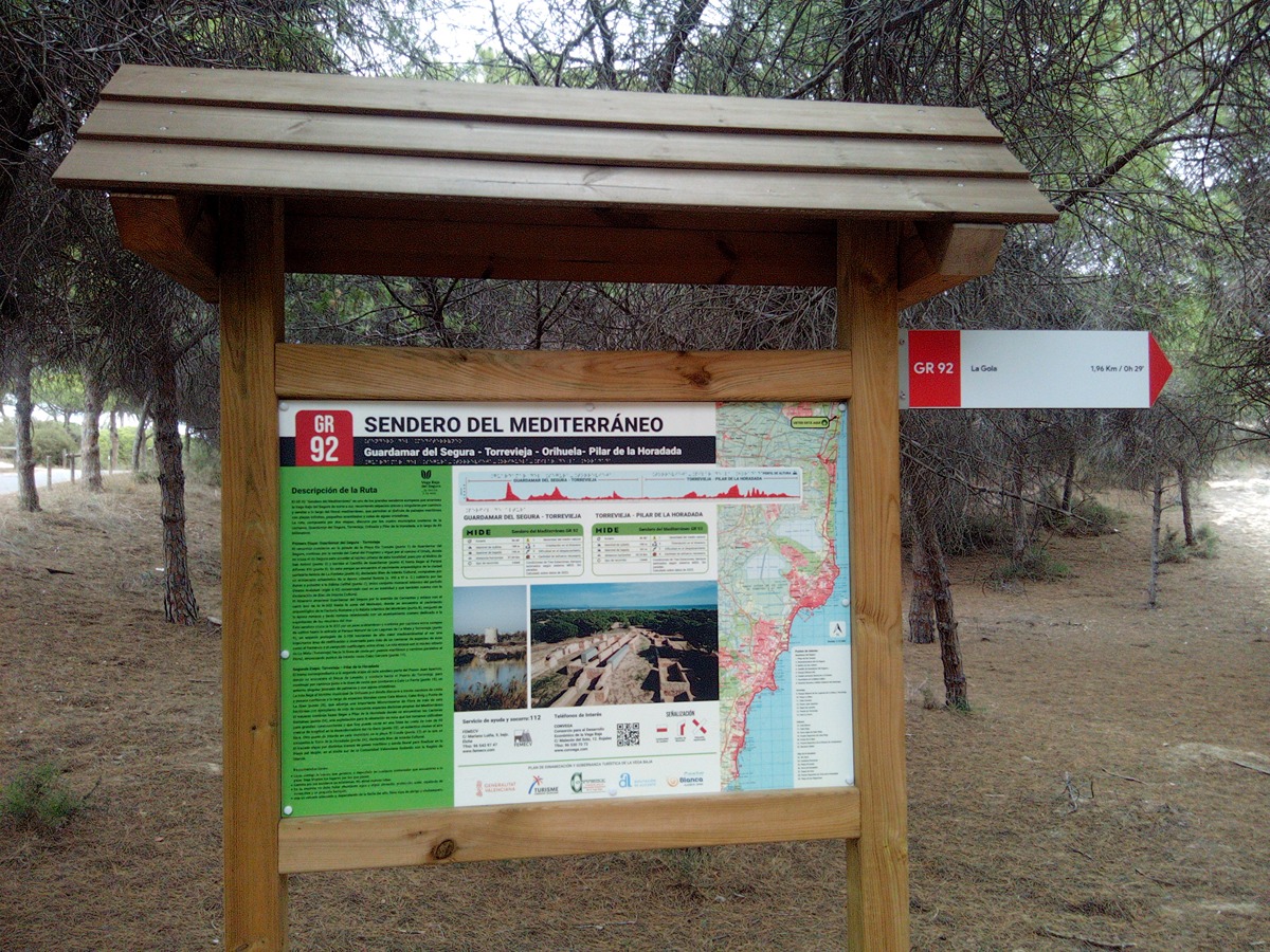
GR 92 E21 GUARDAMAR DEL SEGURA - TORREVIEJA
Promoter: CONVEGA - Consorcio para el Desarrollo Económico de la Vega Baja
Certification status: Valid
Etapa número: 21
Reference municipality:
Guardamar del Segura
Length:
27,00 km
Estimated walking time:
07:15:00
Elevation gain:
255 m
Elevation loss:
255 m
(29)
GR 92 E22 TORREVIEJA - PILAR DE LA HORADADA
Promoter: CONVEGA - Consorcio para el Desarrollo Económico de la Vega Baja
Certification status: Valid
Etapa número: 22
Reference municipality:
Torrevieja
Length:
21,40 km
Estimated walking time:
05:40:00
Elevation gain:
160 m
Elevation loss:
160 m
(67)