Rate this trail

PR-CV 466.1 LLÍBER PEL CAMÍ VELL DE GATA

Promoter: Ayuntamiento de Gata de Gorgos y Ayuntamiento de Llíber

Certification status: Valid

0 reviews

This route makes use of the old road from Gata to Llíber as an alternative to the main route.

Trail:
One way (point-to-point)
Technical data:
Length:
2,50 km
Estimated walking time:
00:45:00
Elevation gain:
90 m
Elevation loss:
60 m
MIDE ratings:
Level of natural risks:
2
Navigation on the trail:
2
Hiking difficulty:
2
Fitness level needed:
1

More information on Montaña Segura

Difficulty rating according to FEDME:
Unknown
Useful information:
Date of certification:
09-07-2022
Reference municipality:
District:
Province:
Alicante/Alacant
Cartography IGN MTN25:
822-2 y 822-4

Downloadable from the Catalogue of the IGN Map Library

Protected Natural Spaces:

We advise you to look up the regulations and/or authorisations for using the trails in these conservation areas on the website of the Conselleria de Medio Ambiente, Agua, Infraestructuras y Territorio

  • Riu Gorgos (SIC - Site of Community Interest)
Weather information:
Key points of the route:

Racó de Gorgos Road - Ctra. CV-748 (road) - PR-CV 53.5 connection - Llíber

Route description (only available in Spanish)

Dejamos el río para tomar un antiguo camino que asciende por la umbría poco a poco por un barranco paralelo a la CV-748. Unos 15 minutos después la densa vegetación va dejando paso a bancales cultivados, casas de campo y algún chalet hasta enlazar con un tramo asfaltado que seguimos recto en fuerte pendiente. Cruzamos la carretera de Gata y recuperamos el firme tradicional para, al poco, encontrarnos con el PR-CV 53.5 que enlaza con Senija. Cruzamos nuevamente la carretera y en el cruce de caminos la variante desciende por la izquierda, por el camí de la Bassa, flanqueado por algún diseminado, hasta la entrada de Llíber para callejear hasta el panel informativo que está en el otro extremo del pueblo.

Downloads:

Beware! Navigation devices may fail, batteries may run out of power and devices may break down. Do not use only electronic means to track your activities in the mountains; they must be used as a complement to the map and compass. Get some proper training and enjoy the mountains.

Other trails connecting with this trail
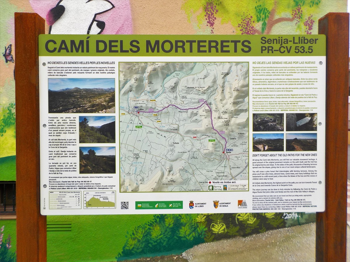