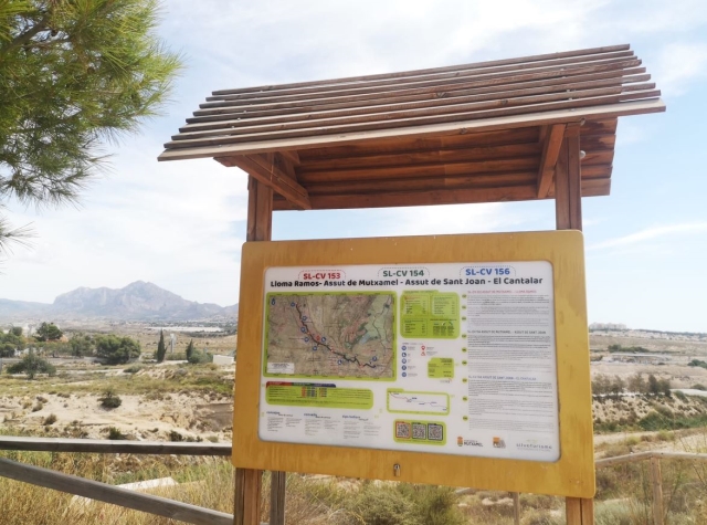
Rate this trail

SL-CV 153 ASSUT DE MUTXAMEL - LLOMA RAMOS

Promoter: Ayuntamiento de Mutxamel

Certification status: Positive quality control

0 reviews
Trail:
One way (point-to-point)
Technical data:
Length:
3,10 km
Estimated walking time:
00:55:00
Elevation gain:
75 m
Elevation loss:
20 m
MIDE ratings:
Level of natural risks:
2
Navigation on the trail:
2
Hiking difficulty:
2
Fitness level needed:
1

More information on Montaña Segura

Difficulty rating according to FEDME:
Unknown
Starting point:
Useful information:
Date of certification:
15-10-2010
Date of the last Quality Control:
july de 2020
Reference municipality:
Otros municipios por los que transcurre:
District:
Province:
Alicante/Alacant
Cartography IGN MTN25:
0872-1

Downloadable from the Catalogue of the IGN Map Library

See other trails of this promoter:
Key points of the route:

La Sabateta recreation area - Assut de Mutxamel (weir) - Molí Nou (mill) - Riu Montnegre Scientific Station - Lloma Ramos (hill)

Route description (only available in Spanish)

Iniciamos el recorrido en el Área Recreativa de la Sabateta, mismo punto de inicio para el sendero SL-CV 154.Descendemos hasta el Assut de Mutxamel y nuestra ruta continua hacia la izquierda, remontando el cauce del río Montnegre. En este mismo punto el SL-CV 154 continúa hacia la derecha.Cotinuamos rrio arriba y cruzamos a la otra margen del río hasta pasar cerca del Molí Nou, al pasar este, cruzamos el río y seguiremos po la senda junto al cauce. Seguimos por la senda hasta y pasaremos un tramo asfaltado, volveremos a cruzar el río, pasando por una Estación Científica de Anillamiento de Aves. El camino continúa por una zona de vegetación muy densa, y comenzaremos a subir por una hondonada en la ladera. Continuaremos bordeando el río por la ladera, por unos antiguos bancales de cultivo colonizados por esparto. El recorrido siempre va lo más cerca posible del cauce, hasta una cárcava que se bordea para coger una senda que se aleja del río y nos lleva hasta la Lloma Ramos punto final de nuestra ruta.

Downloads:

Beware! Navigation devices may fail, batteries may run out of power and devices may break down. Do not use only electronic means to track your activities in the mountains; they must be used as a complement to the map and compass. Get some proper training and enjoy the mountains.

Other trails connecting with this trail