ES / EN / VA

Rate this trail

SL-CV 57 SENDERO DE LA UMBRÍA

Promoter: Ayuntamiento de Puebla de Arenoso

Certification status: No quality controls

3 reviews

There is no proof of quality control on the record of this trail in the last years. For this reason, it is unknown whether it complies with the optimal signage and maintenance conditions for hikers to take the trail following these signs exclusively.
Hikers have to take into consideration that the information about the signage and maintenance of the trails for which the promoter entity is responsible might not be up to date anymore, since it refers to its state on the date of its approval. Furthermore, mountain sports entail risks associated with the activity itself and the environment where they take place, for which any person is fully liable. For this reason, hikes need to be planned properly and adequate training, equipment and sensible use of the trails are required.

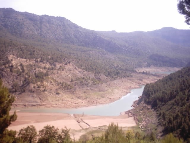
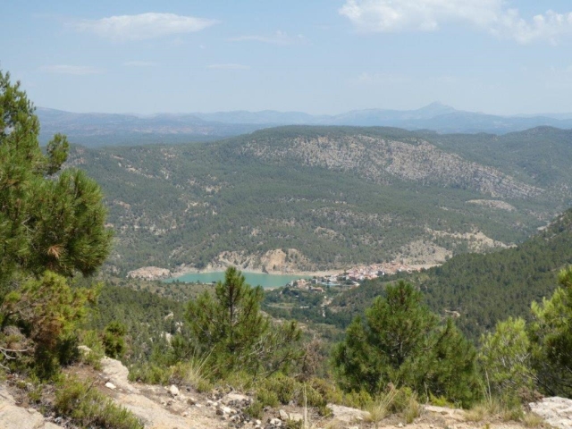
A circular trail that runs through old country estates, springs and the most iconic spots in the municipality of Puebla de Arenoso in the Alto Mijares region. This varied route alternates between paths that pass through thick woods on the shaded side and forest tracks among old abandoned farmland with breathtaking views of the surrounding mountain ranges and the valley of the Mijares river.

Trail:
Loop with some overlapping out and back sections
Technical data:
Length:
10,10 km
Estimated walking time:
03:45:00
Elevation gain:
585 m
Elevation loss:
585 m
MIDE ratings:
Level of natural risks:
1
Navigation on the trail:
2
Hiking difficulty:
2
Fitness level needed:
3

More information on Montaña Segura

Difficulty rating according to FEDME:
Unknown
Useful information:
Date of certification:
15-04-2004
Date of the act of registration in the Public Register:
20-10-2015
Date of the last Quality Control:
june de 2019
Reference municipality:
District:
Province:
Castellón/Castelló
Cartography IGN MTN25:
0614-2

Downloadable from the Catalogue of the IGN Map Library

See other trails of this promoter:
Protected Natural Spaces:

We advise you to look up the regulations and/or authorisations for using the trails in these conservation areas on the website of the Conselleria de Medio Ambiente, Agua, Infraestructuras y Territorio

  • Curso Alto del río Mijares (SIC - Site of Community Interest)
  • Sierra de Espadán y Curso Alto del Mijares (SIC - Site of Community Interest)
Key points of the route:

Puebla de Arenoso (GR 160 and PR-CV 126) - Chorrador de l'Ombría (waterfall) - La Carrasquica - Pilón de Cuatro Caminos (roadside shrine) - Loma la Grana (peak) - Fuente de San Miguel (spring)

Route description (only available in Spanish)

Iniciamos el sendero en la avenida de San Miguel de Puebla de Arenoso (enlaces GR 160 y PR-CV 126). Tras cruzar la carretera CV-20 subimos por unas escaleras y continuamos por El Calvario hacia el cementerio municipal. Después de dejar atrás el cementerio el GR 160 y el PR-CV 126 continúan rectos por el camino y nosotros giraremos a la derecha para seguir por una senda que se adentra en el bosque y que nos lleva al acceso a la fuente y al Chorrador de La Umbría (a 100 metros). El sendero continua por el bosque hasta que llega a unos campos de cultivo y a las ruinas  de la masía de Los Corrales, donde encontramos el acceso a La Carrasquica (a 400 metros) . Un poco más adelante de esta masía se nos unen los senderos GR-160 y PR-CV 126 con los que coincidimos hasta el Pilón de Cuatro Caminos, aquí los dos senderos se desvían hacia Montanejos y nosotros seguimos por el camino (camino de la Loma) hasta que lo abandonamos  por una senda a la derecha que sube a la Loma de la Grana, el punto más alto nuestra ruta (1.015 metros). Desde esta plana cima comenzamos a bajar por un camino de herradura hasta salir a la pista de El Chorrico donde seguimos rectos cruzando la pista y continuando por el bosque saldremos a un camino en la Fuente de Los Caños. Seguiremos por la izquierda en este camino que tras un corto ascenso nos lleva la Fuente de San Miguel. Desde aquí seguimos por una senda que baja a la Fuente del Almajal donde se nos unen el GR 160 y el PR-CV 126. La senda continua descendiendo y llegaremos así a la carretera CV-20 que seguiremos por la derecha para dejarla enseguida por un senda a nuestra izquierda que nos lleva a la Puebla de Arenoso. Entraremos en esta población por la calle Santa Bárbara y giraremos a la derecha en la calle Aragón, llegaremos así a la plaza de la Iglesia y siguiendo por la calle Loreto llegaremos de nuevo a la avenida de San Miguel, inicio y final de este sendero. 

Downloads:

Beware! Navigation devices may fail, batteries may run out of power and devices may break down. Do not use only electronic means to track your activities in the mountains; they must be used as a complement to the map and compass. Get some proper training and enjoy the mountains.

Other trails connecting with this trail