Rate this trail

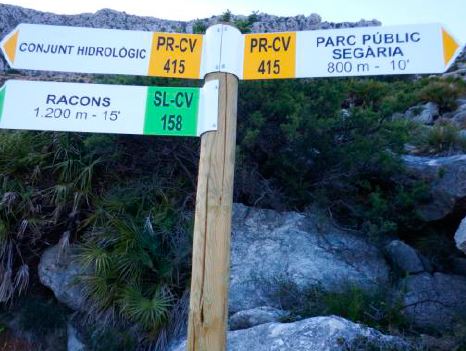
SL-CV 109 LA SEGARIA DE BENIMELI

Promoter: Ayuntamiento de Benimeli

Certification status: Positive quality control

0 reviews

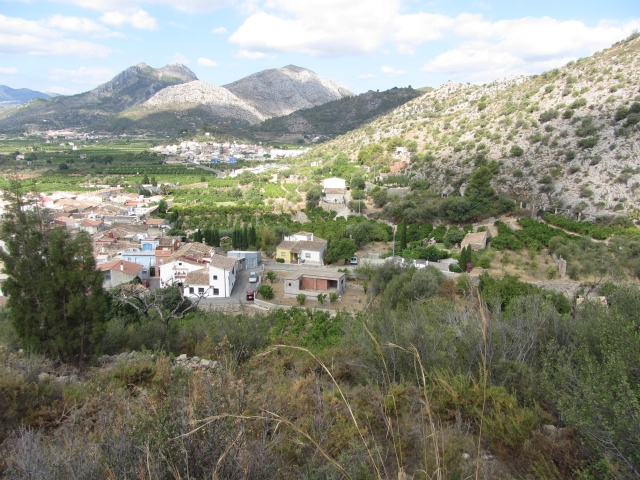
This trail follows a circular itinerary along paths and tracks through the shaded and sunny eastern foothills of the Segària mountain range, which separates the Pego marshland (to the north) from the Girona river valley (to the south). Despite its low altitude (508 metres), it offers magnificent views of the coast and the surrounding mountain ranges.

Trail:
Loop
Technical data:
Length:
4,80 km
Estimated walking time:
02:00:00
Elevation gain:
335 m
Elevation loss:
335 m
MIDE ratings:
Level of natural risks:
1
Navigation on the trail:
2
Hiking difficulty:
2
Fitness level needed:
2

More information on Montaña Segura

Difficulty rating according to FEDME:
Unknown
Starting point:
Useful information:
Date of certification:
18-07-2008
Date of the act of registration in the Public Register:
20-10-2015
Date of the last Quality Control:
july de 2018
Reference municipality:
Otros municipios por los que transcurre:
District:
Province:
Alicante/Alacant
Cartography IGN MTN25:
0796-3; 0822-1

Downloadable from the Catalogue of the IGN Map Library

See other trails of this promoter:
Protected Natural Spaces:

We advise you to look up the regulations and/or authorisations for using the trails in these conservation areas on the website of the Conselleria de Medio Ambiente, Agua, Infraestructuras y Territorio

  • Muntanyes de la Marina (SPAB - Special Protection Area for Birds)
  • Valls de la Marina (SIC - Site of Community Interest)
Key points of the route:

Plaza Mayor de Benimeli (square) - Mirador de les Ombries de Segaria (viewpoint) - Mirador de Segaria (viewpoint) (SL CV 109 spur trail. PR-CV 415 connection) - Pas de Benimeli (mountain pass) (PR-CV 415 connection) - Calvari (Stations of the cross)

Route description (only available in Spanish)

El sendero SL-CV 109 tiene su inicio en la Plaza Mayor de Benimeli junto al Ayuntamiento. Nos dirigimos hacia el norte por la calle "Fora" y salimos de la población para continuar por un camino cementado hasta que tomamos una senda a nuestra derecha que sube por la ladera sur de la sierra de Segaria. Siguiendo  por esta senda cruzaremos una antigua tubería gris y llegaremos en poco tiempo al Mirador de les Ombries de Segaria. Continuamos por la senda hasta llegar a una pista de tierra que seguiremos durante unos 700 metros y cuando la pista traza una curva a la izquierda abandonaremos esta para continuar recto por una senda que sube por la ladera y desemboca en una carretera asfaltada (Camí del Repetidor) que seguiremos a nuestra derecha y que nos llevará al Mirador de Segaria donde tendremos unas extraordinarias vistas de la costa, de la Marjal de Pego-Oliva, del Parque Natural del Montgo y de las sierras interiores. Aquí se enlaza con el sendero PR-CV 415 y también tiene su inicio la derivación al Yacimiento Morisco del SL-CV 109, ambos se dirigen a unas antenas cercanas siguiendo por la carretera, nosotros abandonamos esta para bajar por una senda que nos lleva al Pas de Benimeli donde encontramos un abrevadero y unos pozos antiguos llamados "Les Bassetes". Aquí encontramos también un enlace con el PR-CV 415. La senda gira a la derecha con dirección oeste y continuamos por ella bajando por el barranco del Barranquet que nos lleva al Calvari de Benimeli. Bajaremos entonces por unas escaleras que confluyen en la calle "Calvari" donde giramos a nuestra derecha para continuar por la calle "D´enmig" que nos llevará de nuevo a la Plaza Mayor de Benimeli, inicio y final de este sendero.   

Downloads:

Beware! Navigation devices may fail, batteries may run out of power and devices may break down. Do not use only electronic means to track your activities in the mountains; they must be used as a complement to the map and compass. Get some proper training and enjoy the mountains.

Alternative routes and routes leading to nearby points of interest

Other trails connecting with this trail