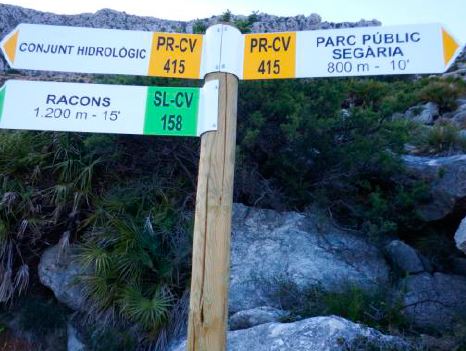
ES / EN / VA

Rate this trail

SL-CV 158 RACONS

Promoter: Grup de Senderisme Beniarbeig

Certification status: Valid

0 reviews

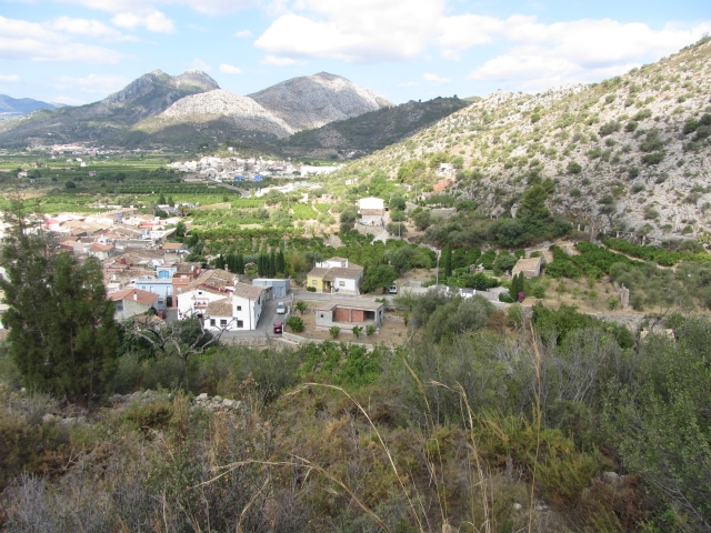
This is an easy trail that offers a wide view of the agricultural and forest area of Beniarbeig. It runs through the fields and forests of the area, accompanied by a panoramic view of the Marina Alta region.

Trail:
Loop with some overlapping out and back sections
Technical data:
Length:
10,50 km
Estimated walking time:
03:35:00
Elevation gain:
325 m
Elevation loss:
325 m
MIDE ratings:
Level of natural risks:
2
Navigation on the trail:
2
Hiking difficulty:
2
Fitness level needed:
3

More information on Montaña Segura

Difficulty rating according to FEDME:
Unknown
Starting point:
Useful information:
Date of certification:
15-07-2017
Date of the act of registration in the Public Register:
04-05-2018
Reference municipality:
District:
Province:
Alicante/Alacant
Cartography IGN MTN25:
0796-4; 0822-1; 0822-2

Downloadable from the Catalogue of the IGN Map Library

See other trails of this promoter:
Protected Natural Spaces:

We advise you to look up the regulations and/or authorisations for using the trails in these conservation areas on the website of the Conselleria de Medio Ambiente, Agua, Infraestructuras y Territorio

  • Muntanyes de la Marina (SPAB - Special Protection Area for Birds)
  • Valls de la Marina (SIC - Site of Community Interest)
Key points of the route:

Plaza 9 de Octubre (square) - Sima de Signes (chasm) - Racó Dels Vinyals - La Basseta (natural pool) - Paso de Benimeli (pass) (PR-CV 415 connection) - El Tossal

Route description (only available in Spanish)

Inicio del recorrido en la Plaza 9 de octubre (Ayuntamiento) hacia el paseo Jaime I. Recorremos el paseo hasta la avd. Rectoría y giramos a la derecha. A unos 280 m giro a izquierda. Llegamos al cementerio y seguimos por la izquierda.A 300 m en el cruce seguimos por la izquierda. A 420 m entramos en la senda a la izquierda. Seguimos por la senda hasta llegar a una casita pequeña y seguimos por el camino asfaltado hasta llegar al camino principal. Giro a la derecha, a 550 m llegamos a una vieja cantera. Giro a la derecha por el camino asfaltado hasta llegar a un antiguo corral de ganado. Seguimos por el camino de hormigón hasta el final, allí giramos a la izquierda entrando en la senda, llegamos a una tubería de agua y seguimos por la senda. A 90 m giro a la izquierda en dirección a la canal, donde giramos a la izquierda enlazando con el PR-CV 415, que viene desde el Parc Public de Segaría. Recorremos toda la canal y al llegar al final bajamos al barranco e iniciamos la subida por la senda de 'Els Racons'. Cuando llegamos arriba, a la derecha podemos ir al conjunto hidrológico de 'Les Bassetes'. Podemos enlazar también con el PR-CV 415 y SL-CV 109 hacia Benimeli. Giramos dirección Este por donde hemos venido y empezamos el descenso por la senda del PR-CV 415 durante 1200 m. Giro a la derecha por el camino asfaltado unos 200 m hasta el primer cruce de caminos que hay y giramos a la derecha. Seguimos por el camino de tierra 200 m y giramos a la derecha entrando en la senda. Al llegar a la cima podemos ver unos pinos, nos dirigiremos hacia ellos bajando por la senda. Salimos al camino asfaltado y vamos 830 m hasta llegar a un cruce de cuatro caminos. Giro a la izquierda y seguimos 560 m hasta llegar al parque público 'Miranbons', lo cruzamos y seguimos por la calle hasta llegar a la Avd. Rectoría. En la avd. Rectoría llegamos al paseo por donde hemos subido. Giro a la derecha por el paseo  hasta que llegamos a la plaza 9 de Octubre, inicio y final del recorrido.

Downloads:

Beware! Navigation devices may fail, batteries may run out of power and devices may break down. Do not use only electronic means to track your activities in the mountains; they must be used as a complement to the map and compass. Get some proper training and enjoy the mountains.

Other trails connecting with this trail